AROURA's interactive GIS portal was developed using ESRI's Arcgis.com online mapping resource. In order to view and interact with AROURA's GIS data on line, you need to fill in the brief appplication form, linked below, and e-mail it to mflane@umbc.edu with the subject heading "AROURA GIS." Successful applications will receive a guest username and password giving access to a read-only GIS interface.
AROURA GIS Portal Application Form (MS Excel format)
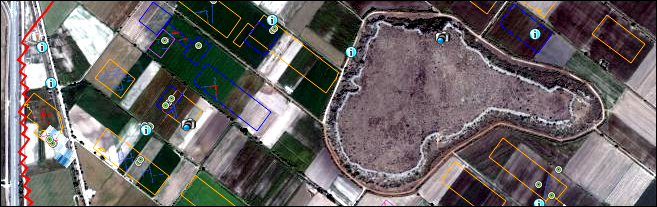
AROURA 2010 - 2012 Geophysical and Surface Survey
If you already have a username and password, click above to log in.
Every on-line archaeological geophysical and surface survey feature is embedded with its data and relevant photographs, and there are also some points of interest and photographs of the team at work.
|